This is the continuation of a trip Jacob, a good friend of mine, and I took at the end of February. We had just spent the second day visiting Joshua Tree National Park and spending time with Jacob's dad. For day three we decided to put some miles in and ride a loop. We were going to visit Calico, an old silver mining town just outside of Barstow. Then make our way east and cross the vast Mojave desert. Finally finishing the day by checking out the old Route 66 town of Amboy.
View Larger Map
Day three started at the same coffee shop as the morning before. The only difference this time was being pulled into a friendly group of bikers who invited us over to chat about bikes and our travels. I'm always amazed how many people you meet once they find out you ride a motorcycle. It's an instant ice breaker. After chatting for half an hour or so, we said our goodbyes, and started heading northwest towards Barstow. It was nice to get back on the road and just open up the throttle. The mountains surrounding Big Bear were off to our left. I would liked to have gone up there and explore if there hadn't been so much snow. Once we hit Barstow we merged onto Interstate 15, uugh superslab, and went a few miles down the road before exiting onto Ghost Town Rd. We filled up at a 76 and, while stretching my legs, I couldn't help but take a picture of this Jenny Rose sign. Unfortunately the restaurant appeared to have closed down quite some time ago. I wonder if Jenny has moved onto bigger and better things.

We arrived at Calico around noon on a Monday morning. Not many people in the parking lot.
Calico is billed as a ghost town, but I would label it more as an old west tourist town. Which isn't a bad thing. Tucson has something similar call
Old Tucson Studios. It's a place you can take the family if you want to feel like you've stepped back into the 1800's. Jacob told me the last time he had been here was during a fourth grade field trip.
The horses were ready to ride, but there was a lack of little kids screaming at their parents "Please! Please! Please!". What's a horse to do?
Jacob and I wandered down main street, six shooters at the ready. Looked like the local fire department was prepared for anything. Budget cuts seem to be affect though, their modern firetrucks had been downgraded to older models.
Lucy Lane's home. Which probably doesn't mean much until you have....
her history!! Just think, when Lucy moved into this house the events in season three of Downton Abby were taking place. HOW could they do that to Matthew? I mean seriously!
We strolled through the various shops...
Before heading up towards the old mines.
One of the cooler buildings in the entire town.
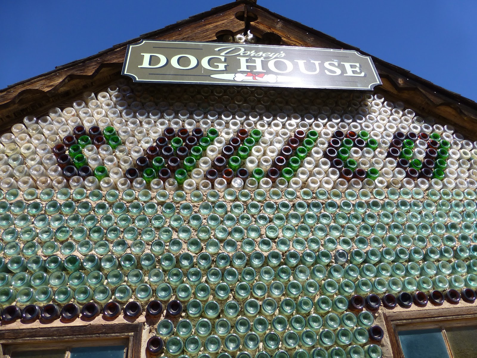
Dorsey's Dog House is a pet shop made out of old bottles! Turns out that Calico allows dogs inside the park. I looked it up and they charge one dollar entrance fee per dog.
I just got a kick out of the building material.
Inside, the walls reminded me of stained glass.
We proceeded farther up hill until we made it to Maggie Mine. This picture was taken for the guys in the office to chuckle at. Some low brow humor there:) Anyway the sign reads "The Maggie Mine Glory Hole, near this spot in 1882 a school boy found a silver bearing rock leading to the discovery of this $65,000 Glory Hole."
From this vantage point we had a nice view over the entire park.
Feeling we'd had our fill of Calico we made our way back to the bikes and continued 60 miles down I15 until we reached Baker, CA. After using a sketchy Shell station we pulled the bikes into a closed Bun Boy parking lot to take a break for water and snacks. We found this lone guardian keeping watch over the Bun Boy empire. The artist's name was still carved into the wood "C White Ft. Bragg '77".
In Baker we cross over I15 and found ourselves at the entrance of the
Mojave National Preserve. Not a flattering picture of me. I set the camera on a 10 second delay and then had to do a mad dash to get into position. I think I made it with 2 seconds to spare.
Two things that stand out as we headed into the Mojave. One was a sign post, with flashing lights, that stated "Watch out for tortoises!". The other was that the road started off fine but deteriorated quickly. It hadn't been resurfaced for who knows how long. The asphalt portion of the road appeared to have washed away leaving large stones, that once served as the inner aggregate, sticking up like spaced out cobblestones. At one point I tried to cross the yellow center line and it had to be and inch or two higher then the surrounding pavement. Needless to say it pushed me back into my lane. A little scary!
After a rough 34 miles we reached the halfway point between I15 and I40 which is the town/train depot of
Kelso. A quick picture in front of the old post office.
This train depot was built in 1923 and operated until 1986. They recently renovated it and did a great job! Check out the size of the palm trees. The next picture shows when they were first planted.
Unfortunately the 3:10 train to Yuma wasn't scheduled. We'd have to continue our trip by motorcycle.
We would have stopped for an old fashion milkshake, but daylight was burning, and we still had a ways to go.
After leaving the park we crossed under I40 and kept heading south until we hit Route 66. As far as I know, the first time I've ever been on it. We reached
Amboy and it was just how I pictured it, middle of nowhere. I'm a big fan of middle of nowhere. Couldn't have asked for a better end of a day/trip, no wind, perfect temperature, good ride.
I failed in that I didn't get any pictures inside of the cafe. There were tons of pictures and neat stuff to look at. I even bought a T-shirt:)
These were the cottages seen in the background of the Harrison Ford picture in my last post. They were empty but appeared to have been freshly painted.
What car?
We wandered around for a bit taking pictures.
One last group photo before heading on. Look bad-ass and say cheese!
A few miles down the road is
Amboy Crater. No, it's not a meteor crater. Which is what I first thought when I heard of it, but instead an extinct volcano. It's believed to be 6000 years old and thought to have last erupted 500 years ago.
We parked the bikes and headed over for a look.
Not a great picture of the cinder cone. Photo was taken with the sun in the background.
Looking east over the surrounding lava fields. Amboy can be seen in the distance. Route 66 heading away into another time.
We made it back into Yucca just after sunset. The Mexican restaurant from two nights ago beckoned us with thoughts of tall margaritas. My wife is always telling me to "step outside the box" when it comes to my food orders. So instead of my usual, chicken fajitas, I changed it up and ordered the pork fajitas. Mmmm! Mmmmm!
The next morning we had to head home. We traveled together until the southern part of the Salton Sea where Jacob headed west and I continued east. We both had a great time and I'm already trying to drag him into my next bike adventure. Trip odometer read 1304 miles. It all went by too fast! Until next time, thanks for reading!


Amazing photos! Blue sky! Route 66 with no cars - what more could a biker want? Way to go!
ReplyDeleteWhat an epic trip. Thanks for sharing all the photos.
ReplyDeleteFore some reason when I picture Lucy Lane I picture Granny from the Beverly HIllbillies.
And every time I've heard the term I've wondered why in the mining industry they have a glory hole. *Snicker*. Wonder who coined that name.
Thanks again for taking us along for the ride.
@Black Inazuma - Thanks!
ReplyDelete@Trobairitz - Haha I know right? That's the kind of personality I envision as well for Lucy. No problem, thanks for the kind words!