Still trying to catch up on my posts. Wanted to show a few photos of a small vacation Kiri and I took at the end of July. It's becoming our yearly visit to Santa Cruz, to see friends, and get away from Tucson for a bit. We flew into San Francisco on a Thursday and thought we'd explore the Sutro Heights portion of San Francisco before driving down the coast.
View Larger Map
We grabbed a quick bite at the Seal Rock Inn Restaurant before wandering around. Always nice to have a window seat with a view.
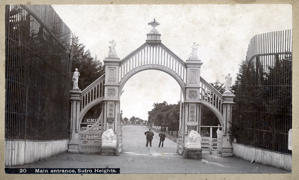
After lunch we began our exploration of Sutro Heights Park. This whole area of San Francisco has some amazing history. The park used to be the home of one of San Francisco's mayors at the end of the 1800's. Kiri is sitting with one of the lions that guarded the entry gate of the estate.
This is what the entrance used to look like. Can you spot Kiri's lion?
The estate was covered with statues. Now only a few survive.
A place to escape the rain if need be. Luckily for us it was just cloudy today.
Up top the mayor built quite the lookout. Who is that dashing young couple??
Looking south, down the coast. The views were amazing!
I thought this tree was just asking to be climbed. Kiri helps me put it in perspective.
After exploring the park we crossed the street and wandered over to the Sutro Baths ruins.
Believe it or not this used to be the site of a indoor swimming area built in the 1890's by our old friend Mayor Sutro. He must have been an amazing character! There were seven pools, one fresh water and six salt water with different temperatures! The baths burned down in 1966 but you can still explore the old ruins.
Here's what the building used to look like from the same angle. Notice the rocks, in the ocean, line up in both photos. (Next three images were found on Google Images.)
And a glimpse of what it looked like inside.
This image shows the old Cliff House in the background.
Same view from our trip. Notice the people wandering the concrete walls down below.
Kiri is smiling because I told her "not to slip" and "the water sure looks cold!". She responded with some kind words about me closing my trap, otherwise she was going to "show me just how cold it was."
In the same area you can explore old caves that lead to a nice view of the ocean.
We could see cargo ships coming in from the Pacific.
And the Golden Gate Bridge off in the distance. The low cloud cover prevented us from seeing the top of the bridge.
This portion of San Francisco also has the Land's End Trail. A nice hiking trail that Kiri and I stumbled upon a few years ago by accident. Every time we come back to San Francisco we try to go visit it. The little jut of land in the center of the picture is called Eagle's Point and it usually has a hidden labyrinth design on it.
Here's Kiri sitting at the center.
I dug back through our old photo archive and found this picture of Kiri at the same location in 2006.
One last shot from the trail before we have to head back to the car and drive towards Santa Cruz.
From San Francisco we took Highway 1 south to a small resort that Kiri and I wanted to visit called Costanoa Lodge.
View Larger Map
We had wanted to stay here a couple of years ago but it didn't work out. So this time Kiri and I decided to go for it. You have a couple of accommodation options if you stay here. You can, of course, stay in the lodge. Or try one of the small rustic cabins.
We decided to stay in a tent bungalow!
Home sweet home for our weekend getaway!
This wasn't your normal tent. It comes with a super comfy bed and heated blankets!
Our view of the coastal hills while preparing for a serious power nap.
We had stopped at a groceries store on the way and picked up a few necessities. Strawberries, almonds, goat cheese, and some nice sourdough bread. And a little wine to wash it all down. Camping has gotten a lot easier from when I was a kid:)
I'll try to finish this trip off tomorrow! Thanks for following along!
Sunday, October 20, 2013
Thursday, September 26, 2013
Colorado Trip 2013 - Part VII (The End)
Just a quick post to finish off this adventure. This is the final segment of a amazing trip my dad and I took to Colorado back in May of 2013. Having spent the night in Kanab, Utah we broke camp early and started heading south on highway 89A where we quickly crossed back into Arizona.
View Larger Map
This is at the Le Fevre Overlook in the Kaibab National Forest. We met a couple, visiting from England, who agreed to take our picture.
From here you have an amazing view of the The Grand Staircase to the north. On a sad note, two months after my dad and I stopped here a couple was hit by lightning at this same location. The lightning struck just to the left of where my dad is standing in the above picture.
After crossing through Kaibab we came to a overlook where we could see the Vermillion Cliffs off in the distance.
We had some cloud cover in the morning which gave us a break from the heat, but also added a nice surreal effect to the ride.
Looking down you could see highway 89A stretching off into the distance.
And here are the Vermillion Cliffs up close. We pulled over at Lee's Ferry to walk out over the old Navajo Bridge. This is the last bridge crossing over the Colorado for quite some distance. There's a little hole in the ground called the Grand Canyon which prevents north/south travel. Heading west, your next bridge crossing is at the Hoover Dam.
There are two bridges here. The old one was completed in 1928 and used all the way up to 1995, when a new bridge was built. The new bridge is what you're looking at here.
The Colorado river looked like bluish green glass at the bottom of the canyon.
This is looking across the older bridge. They allow people to walk out on it.
Looking east we could see a couple of rafting tours coming down the river.
I zoomed in to see what they were up to.
Back in ~2002 Kiri and I were lucky enough to take one of these rafting trips down the Grand Canyon. Trip of a lifetime! There's a long waiting list to get on these trips though, so sign up soon! I believe this is the company that Kiri and I used: HERE.
The older bridge is much narrower then the new bridge. Can you imagine two semi trucks crossing in this space??
From Lee's Ferry we headed south, through Flagstaff, and then southwest into Oak Creek Canyon. We met a fellow rider there who chatted us up and was nice enough to take our picture.
The road drops down into this canyon is about 5 or 6 hairpin turns. Amazing ride if you're ever in the area.
After Oak Creek the temperature really started to soar. We passed through the towns of Sedona and Cottonwood before making it to my Uncle Sid's house in Prescott.
The required glass of margarita once you reach his place. He makes a mean margarita! We spent the night before making the final push towards home.
The next morning we left early and still couldn't beat the heat. You forget what hot is after spending time at higher altitudes.
Last shot of the trip. This is at a gas station outside of Tucson. It was so hot we had to pull over and cool ourselves down by pouring cold water all over our shirts. It was a great trip and we were already talking about our next adventure. Thanks for following along! Until next time!
Sunday, September 22, 2013
Colorado Trip 2013 - Part VI
Like I said, I need to catch up so here's the next post. We'll be moving fast so try to keep up!
We spent a restful night in the town of Huntington, UT and woke up eager to see more of what the state had to offer.
View Larger Map
Breakfast that morning was powdered donuts and Coke Zero at the nearest gas station. Forty miles later we pulled over at a nice rest stop, in the town of Emery, so I could use the faculties. Nothing serious..I just needed to use the bathroom. My dad checked out the local history of the area.
On the last post I mentioned we missed our turn off and had to go over a summit twice. I was incorrect. It actually happened this day on Interstate 70. We missed the Fremont Junction and ended up going over a 7900' summit twice. Eventually we got our bearings and took highway 72 south.
It's hard to pick your favorite day on a motorcycle trip. Since you're not at work, everyday is a great day:) But I really enjoyed the roads through Utah on this particular day. Spectacular riding!
The theme of today's trip was vistas. And we saw quite a few of them.
We were in the Fishlake National Forest. Beautiful country! If you ever get a chance to visit Utah, make sure you drive through this area!
Sweeping roads following meadow streams.
At one point we arrived at a fork in the road. I was pretty low on gas but my dad noticed the map showed a nice road curving around Fishlake. I was nervous about the additional miles and mentioned "Not sure if I can make that." His reply? "Ah you can make that, lets go!" So off we went. In the end my dad was right. We got to see a some more amazing country and I rolled into the town of Loa with mileage reading 148 miles and my reserve light not even lit up yet.
We headed east out of Loa on highway 26. Our first signs of sandstone cliffs appeared behind some green pastures with grazing buffalo! After _not_ stopping for pictures of pronghorn sheep I knew I'd better pull over for buffalo.
Summer was approaching so it looked like they were shedding their winter coats?? Just a guess.
Tatanka!
I liked the color transition of the lush green next to the rusty orange.
We turned south onto highway 12 and entered the Dixie National Forest. The amazing views just kept on coming!
I actually made a u-turn to come back to this look out. I'm sure my dad was getting tired of taking pictures every few miles.
Looking out to the east you're able to see the Capitol Reef National Park. According to Wiki the park got it's name from the domes and cliffs of white sandstone that look like the Capitol building in Washington D.C.
Pa no-ramic!
We saw quite a few people biking their way across the southwest on our trip. This guy was leaving the lookout when we pulled in. No matter how rough you think you're traveling, there's always someone else doing it harder/better.
Vista-terrific!
We stopped for lunch at a place called Burr Trail Grill, park of a larger resort near the town of Boulder.
While the place was nice, we just happen to get there at the wrong time and it took a really...really long time to get our food.
I made the critical mistake of ordering a blue cheese cheeseburger. It sounded great until I realized I hate blue cheese. Let's eat something that tastes like dirty socks. Blue Cheese will never be ordered by me again!
After a lunch to be forgotten, we headed farther south into the Escalante National Monument. This place has to be visited to be believed. There's no way I can properly describe it and do it justice. The road was paved over vast endless sandstone formations. The temperature was just starting to get toasty. Not sure I'd want to visit in the middle of August:)
Be sure to click on this photo and see if you can follow the road and it snakes out to the left. It was a neat road to ride.
Pa no-ramic!
We started descending down the Grand Staircase. We pulled over to snap a picture of Powell Point off in the distance. I took some more pictures of it from the west side, in the town of Tropic.
Some motorcyclists going by as we were getting back on our bikes.
As promised, Powell Point off in the distance. "Powell Point was named after John Wesley Powell, who led expeditions in the late 1800s to map this region which at that time was one of the last “blank spots on the map” of the continental U.S." (source)
We buzzed through Bryce Canyon National Park. I should have pulled over and taken more pictures, but we were getting tired and I had visited this area once before while in college. Take a gander of what's there via Google images:)
We made camp in Kanab, UT at a place called Crazy Horse RV Camp park. Not a five star location, but the owners were very nice and let me borrow some of their laundry detergent, for free, to do some laundry.
That evening my dad and I walked down the road for dinner at a Mexican restaurant. On the way back we passed the Kanab City Cemetery. It was Memorial day and the main entry of the cemetery was lined with flags. There was a extremely bright light, at the end of the road, giving some nice back lighting to the Red, White and Blues. With the large cliff in the background I was suddenly reminded of what a great country we live in and the people who gave their lives to make it so. Until next post, stay safe out there. Thanks for reading.
We spent a restful night in the town of Huntington, UT and woke up eager to see more of what the state had to offer.
View Larger Map
Breakfast that morning was powdered donuts and Coke Zero at the nearest gas station. Forty miles later we pulled over at a nice rest stop, in the town of Emery, so I could use the faculties. Nothing serious..I just needed to use the bathroom. My dad checked out the local history of the area.
On the last post I mentioned we missed our turn off and had to go over a summit twice. I was incorrect. It actually happened this day on Interstate 70. We missed the Fremont Junction and ended up going over a 7900' summit twice. Eventually we got our bearings and took highway 72 south.
It's hard to pick your favorite day on a motorcycle trip. Since you're not at work, everyday is a great day:) But I really enjoyed the roads through Utah on this particular day. Spectacular riding!
The theme of today's trip was vistas. And we saw quite a few of them.
We were in the Fishlake National Forest. Beautiful country! If you ever get a chance to visit Utah, make sure you drive through this area!
Sweeping roads following meadow streams.
At one point we arrived at a fork in the road. I was pretty low on gas but my dad noticed the map showed a nice road curving around Fishlake. I was nervous about the additional miles and mentioned "Not sure if I can make that." His reply? "Ah you can make that, lets go!" So off we went. In the end my dad was right. We got to see a some more amazing country and I rolled into the town of Loa with mileage reading 148 miles and my reserve light not even lit up yet.
We headed east out of Loa on highway 26. Our first signs of sandstone cliffs appeared behind some green pastures with grazing buffalo! After _not_ stopping for pictures of pronghorn sheep I knew I'd better pull over for buffalo.
Summer was approaching so it looked like they were shedding their winter coats?? Just a guess.
Tatanka!
I liked the color transition of the lush green next to the rusty orange.
We turned south onto highway 12 and entered the Dixie National Forest. The amazing views just kept on coming!
I actually made a u-turn to come back to this look out. I'm sure my dad was getting tired of taking pictures every few miles.
Looking out to the east you're able to see the Capitol Reef National Park. According to Wiki the park got it's name from the domes and cliffs of white sandstone that look like the Capitol building in Washington D.C.
Pa no-ramic!
We saw quite a few people biking their way across the southwest on our trip. This guy was leaving the lookout when we pulled in. No matter how rough you think you're traveling, there's always someone else doing it harder/better.
Vista-terrific!
We stopped for lunch at a place called Burr Trail Grill, park of a larger resort near the town of Boulder.
While the place was nice, we just happen to get there at the wrong time and it took a really...really long time to get our food.
I made the critical mistake of ordering a blue cheese cheeseburger. It sounded great until I realized I hate blue cheese. Let's eat something that tastes like dirty socks. Blue Cheese will never be ordered by me again!
After a lunch to be forgotten, we headed farther south into the Escalante National Monument. This place has to be visited to be believed. There's no way I can properly describe it and do it justice. The road was paved over vast endless sandstone formations. The temperature was just starting to get toasty. Not sure I'd want to visit in the middle of August:)
Be sure to click on this photo and see if you can follow the road and it snakes out to the left. It was a neat road to ride.
Pa no-ramic!
We started descending down the Grand Staircase. We pulled over to snap a picture of Powell Point off in the distance. I took some more pictures of it from the west side, in the town of Tropic.
Some motorcyclists going by as we were getting back on our bikes.
As promised, Powell Point off in the distance. "Powell Point was named after John Wesley Powell, who led expeditions in the late 1800s to map this region which at that time was one of the last “blank spots on the map” of the continental U.S." (source)
We buzzed through Bryce Canyon National Park. I should have pulled over and taken more pictures, but we were getting tired and I had visited this area once before while in college. Take a gander of what's there via Google images:)
We made camp in Kanab, UT at a place called Crazy Horse RV Camp park. Not a five star location, but the owners were very nice and let me borrow some of their laundry detergent, for free, to do some laundry.
That evening my dad and I walked down the road for dinner at a Mexican restaurant. On the way back we passed the Kanab City Cemetery. It was Memorial day and the main entry of the cemetery was lined with flags. There was a extremely bright light, at the end of the road, giving some nice back lighting to the Red, White and Blues. With the large cliff in the background I was suddenly reminded of what a great country we live in and the people who gave their lives to make it so. Until next post, stay safe out there. Thanks for reading.
Subscribe to:
Posts (Atom)