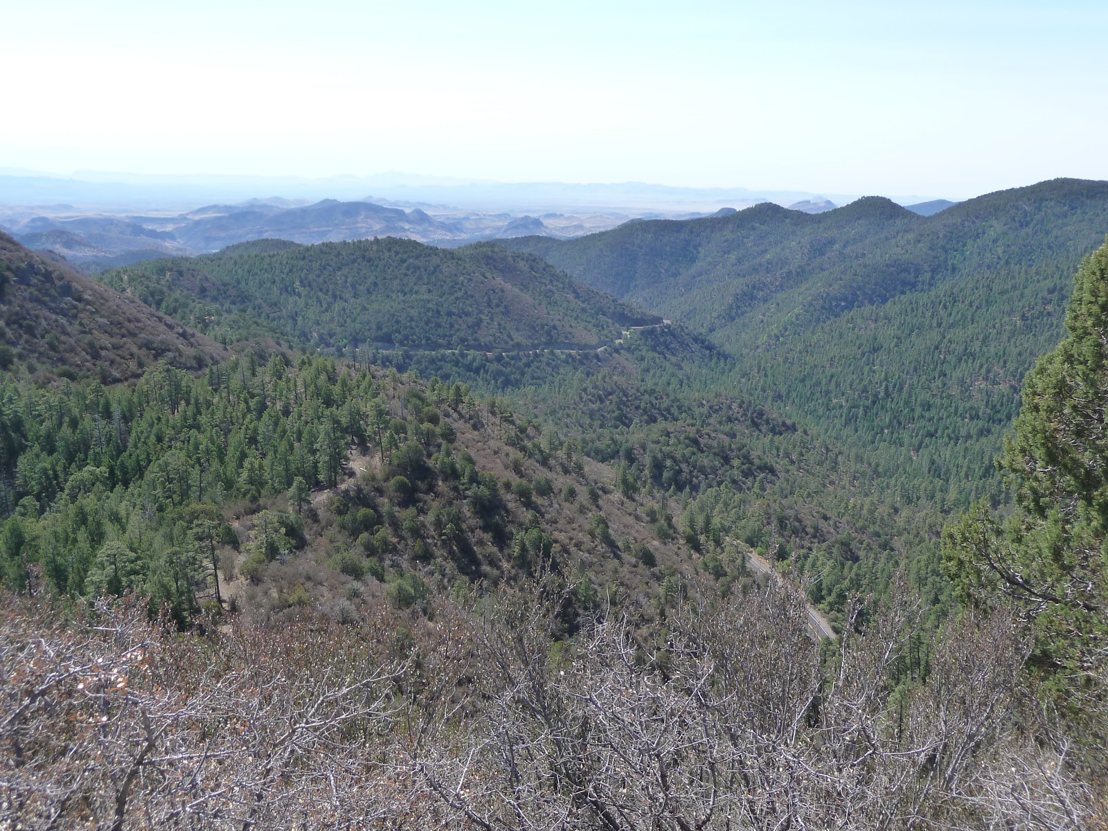
Day 8! So close to home I could feel it. Vern had been on the trip since Las Vegas and was eager to get back, so he decided to make the last push to Tucson in one day. While getting home a day early would have been great, some part of me didn't want the adventure to end. So I decided to skip the interstate and add one more night in Safford. I could finish the last few miles to home the next morning when it was cooler. Safford was 308 miles away with a few small detours through the Gila National Forest.
View Larger Map
One last shot of Vern before he headed home. I couldn't have asked for a nicer riding partner. We got along well and he never got frustrated with me always wanting to snap one more picture.
While some people may think riding alone would be miserable, on a bike it gives you a lot of benefits. You don't have to worry about setting a certain pace. You can stop whenever and wherever you like. And it gives you that solitary "out on the open road" "wandering spirit" feeling. I was looking forward to having one day just to myself.
After filling up with gas I tried stopping at the local McDonalds. As I walked in there was a long line of early morning patrons. I asked an older gentleman if it was always this slow and he was quick to point out that most of the employees must have slept in, because he had never seen such bad service as today. I told him I'd see if the service in the Truth or Consequences McDonalds was any better. He laughed and wished me luck as I headed out the door.
Service in Truth or Consequences was _much_ better and after a few minutes I had my breakfast. I didn't forget to take a picture this time and slowly sipped my coffee while going over my route. Even through I could pull up maps on my phone, I did bring a paper map of each state we passed through.
Shortly after leaving ToC, I turned off the interstate at highway 152. This was the scenic route heading to Silver city. Let me tell you, this was the coolest "motorcycle" road I encountered on the entire trip. I'll link a small section of map that shows crossing over Emory pass.
View Larger Map
Most of the curves were posted at 10 to 15mph and the elevation got up to ~7600 feet. I hadn't expected this portion of road to be so good. It caught me by surprise and ended up being the cherry on top of a great trip.
Here was the view at the top of the pass. This was looking out towards the town of Kingston where you start to climb up into the hills.
And here you can make out some of the road leading up to the pass.
The whole enchilada.
I shared the view with a couple of bicyclists. I saw quite a few making their way up the mountain. It must be pretty rewarding to make it to the top on your own power.
From here you head back down in elevation to the town of San Lorenzo. It started getting hot again. I got a little worried as there was supposed to be a gas station in the area but the one in San Lorenzo was closed down. I was pretty sure there was one in the town of Mimbres..but if I couldn't find it I'd have to change course and take the shorter route to Silver City. Luckily Google street view didn't lie and I found my gas station. It was the most rustic one on the whole trip.
From here I headed north into the Gila National Forest. It kind of let me down as I was hoping for cooler temps, and even through I was at 6000' it never got cool. As a matter of fact the whole place felt like a tender box. There were _extreme_ fire danger signs everywhere. One cigarette butt from a careless smoker and it would have been a disaster.
I made it to Lake Roberts and snapped a picture. I didn't sit long as I was already sweating. Once the raining season starts I'm sure this area would be much more enjoyable.
Shortly after the lake the road had just been chip sealed. For those of you who don't know what that is, they spray fresh tar on the road and then cover it with plenty of gravel to create a new road surface. I ended up driving ~20 miles back towards Silver City on loose gravel, oh and did I mention there were plenty of curves. I may have cussed a few times.
At this point the temperature was really starting to climb, so I filled up with gas in Silver city and proceeded to get lost trying to make my way out of town. I always get turned around in that town. I headed north to mule creek road and back over into Arizona.
I made it to Safford around 2pm and I'm glad I wasn't driving the rest of the way to Tucson. I'm sure it was 110 degrees in the sun by that point. I called up a cousin that lived in Safford and was able to meet him for dinner at a nice Mexican restaurant. Of course I forgot to take any pictures. Fail.
The next morning I got up early and headed home. About ~127 miles.
View Larger Map
After kissing the wife and dog, I checked the milage...
Woo hoo 2818.6 miles! My longest trip on the bike, and first time out of the state with her. I had a blast and can't wait to get out there again.
For those who have been reading along, thanks! Sorry for taking so long to finish. I have my next trip in two weeks..so stay tuned.
If you enjoyed the trip and can't get enough, please take a look at one of my favorite bloggers. He's kind of my inspiration for buying the bike and getting out on the open road. AND he's currently out on a trip right now...so check him out at
http://mybonnie.wordpress.com/
Thursday, August 18, 2011
Monday, August 15, 2011
2818 miles on a Bonneville - Day 7
I know I know, I kinda stopped posting. No real excuse other then the fact that I've been lazy and work has been stressing me out. My Aunt emailed me last night and threatened to hunt me down if I left the trip hanging in Amarillo. So here we go...the next leg ended up being ~394 miles..which kinda makes me a liar. I said my longest leg was 370 miles back on post "day 2". Never make bold statements early in your trip descriptions. For all my younger readers out there you should be writing this down. Life lessons learned the hard way, free of charge.
View Larger Map
Our goal for day seven was Socorro, New Mexico. Let me warn you that this day/post is light on pictures. For some reason I stopped using the camera. I can give you a long list of excuses, but it boils down to the fact that unless you really make the effort to document your trip it's very easy to slip into a mode of just living the trip or existing in it. There's nothing wrong with that, but it's hard to translate that trip into blog post without pictures, and so you must constantly remind yourself to whip out the camera as much as possible. Easier said then done.
If you remember from the last post Vern and I stayed at separate hotels in Amarillo. So we agreed to meet at a familiar location in the morning. What's more familiar then the place you stuffed your face the night before. That's right! The Country Barn.
Not going to sugar coat it here. I was scared of the heat we encountered the day before. So Vern and I agreed to leave as early as possible. "Early as possible" means 6am in Texas.
From here we caught the the freeway south until interstate 60 where we started heading southwest to the boarder of New Mexico. What can I say. A lot of straight, flat riding. We passed through plenty of towns that all seemed to make their living on cattle. We made pretty good time, and eventually we crossed over into New Mexico. We were supposed to be in Farwell, but kept seeing signs that said Texico. It took us awhile to realize the town changed names depending on which state you were in.
From here we made our way to Roswell. I know what you're thinking...how can you not take pictures in Roswell. It's just a normal town overall. Yeah you see the plastic green space men on the outside of stores and on signs..but I was more concerned with how hot it was getting. It was only 11am and I was starting to sweat..so we made a beeline for a subway and mapped out our next destination. To be fair, Vern he did ask if I wanted to stop and get pictures with plastic space men..but I declined. Maybe it was the fact that we were getting close to home and I could already see my wife and dog over the horizon.
While we ate our sandwiches I broke out the New Mexico map and started looking at a change of path. Our original path had us going through Capitan, but Vern used to live in the area back when he was in the military and mentioned we could go see Ruidoso and the Ruidoso Downs racetrack. More important to me was that it was at 6500' elevation. The decision was made..and we were off.
I'm going to cop out and just link a history of the area that I found on a reality web site. Wikipedia failed me. Feel free to buy a house while you're at their site:) Needless to say the area was very cool. I saw little breweries, shops, and restaurants. If I could do it again I would have found a hotel there and spent the rest of the day exploring the area. Alas, we just filled up with gas and continued on our way.
Coming down out of the mountains we entered the "Valley of Fire". From a long way off you can see a large section of the valley floor with a dark spot sitting in the center. As we got closer the spot became larger and larger until starts to encompass you. And then you enter the lava fields.
Basalt lava, like it formed yesterday, is everywhere. Imagine the lava you see oozing out of volcanoes in Hawaii and you have an idea of what this looked like. Vern had come through this area years before and said that if you drive through the area at twilight, by yourself, the whole landscape can become very spooky. It's very hard to explain, but you almost feel like you're on another planet. Like a rocky moon or something.
From here we drove west to Socorro. We crossed the top of the White Sands missile range. Only a few miles from where the first nuclear bomb was set off at the Trinity test site. Vern told me they allow the public to visit the area twice a year. I would have loved to see it.
We arrived in Socorro in late afternoon. Another top of the line hotel...that's sarcasm if you didn't pick up on it. The place was only slightly better then in Oakley. We walked across the road to enjoy some pizza and beer before calling it a night.
Stay tuned for tomorrow when I post Day 8 and 9 and the end of the adventure!!!
View Larger Map
Our goal for day seven was Socorro, New Mexico. Let me warn you that this day/post is light on pictures. For some reason I stopped using the camera. I can give you a long list of excuses, but it boils down to the fact that unless you really make the effort to document your trip it's very easy to slip into a mode of just living the trip or existing in it. There's nothing wrong with that, but it's hard to translate that trip into blog post without pictures, and so you must constantly remind yourself to whip out the camera as much as possible. Easier said then done.
If you remember from the last post Vern and I stayed at separate hotels in Amarillo. So we agreed to meet at a familiar location in the morning. What's more familiar then the place you stuffed your face the night before. That's right! The Country Barn.
Not going to sugar coat it here. I was scared of the heat we encountered the day before. So Vern and I agreed to leave as early as possible. "Early as possible" means 6am in Texas.
From here we caught the the freeway south until interstate 60 where we started heading southwest to the boarder of New Mexico. What can I say. A lot of straight, flat riding. We passed through plenty of towns that all seemed to make their living on cattle. We made pretty good time, and eventually we crossed over into New Mexico. We were supposed to be in Farwell, but kept seeing signs that said Texico. It took us awhile to realize the town changed names depending on which state you were in.
From here we made our way to Roswell. I know what you're thinking...how can you not take pictures in Roswell. It's just a normal town overall. Yeah you see the plastic green space men on the outside of stores and on signs..but I was more concerned with how hot it was getting. It was only 11am and I was starting to sweat..so we made a beeline for a subway and mapped out our next destination. To be fair, Vern he did ask if I wanted to stop and get pictures with plastic space men..but I declined. Maybe it was the fact that we were getting close to home and I could already see my wife and dog over the horizon.
While we ate our sandwiches I broke out the New Mexico map and started looking at a change of path. Our original path had us going through Capitan, but Vern used to live in the area back when he was in the military and mentioned we could go see Ruidoso and the Ruidoso Downs racetrack. More important to me was that it was at 6500' elevation. The decision was made..and we were off.
I'm going to cop out and just link a history of the area that I found on a reality web site. Wikipedia failed me. Feel free to buy a house while you're at their site:) Needless to say the area was very cool. I saw little breweries, shops, and restaurants. If I could do it again I would have found a hotel there and spent the rest of the day exploring the area. Alas, we just filled up with gas and continued on our way.
Coming down out of the mountains we entered the "Valley of Fire". From a long way off you can see a large section of the valley floor with a dark spot sitting in the center. As we got closer the spot became larger and larger until starts to encompass you. And then you enter the lava fields.
Basalt lava, like it formed yesterday, is everywhere. Imagine the lava you see oozing out of volcanoes in Hawaii and you have an idea of what this looked like. Vern had come through this area years before and said that if you drive through the area at twilight, by yourself, the whole landscape can become very spooky. It's very hard to explain, but you almost feel like you're on another planet. Like a rocky moon or something.
From here we drove west to Socorro. We crossed the top of the White Sands missile range. Only a few miles from where the first nuclear bomb was set off at the Trinity test site. Vern told me they allow the public to visit the area twice a year. I would have loved to see it.
We arrived in Socorro in late afternoon. Another top of the line hotel...that's sarcasm if you didn't pick up on it. The place was only slightly better then in Oakley. We walked across the road to enjoy some pizza and beer before calling it a night.
Stay tuned for tomorrow when I post Day 8 and 9 and the end of the adventure!!!
Sunday, July 3, 2011
2818 miles on a Bonneville - Day 6
Our goal for day 6 was Amarillo, TX. It would be a long ~350 miles. Every trip has a high and low day and this would end up being my least favorite leg of the adventure.
View Larger Map
The rain from the previous evening had soaked my mesh jacket and pants, jeans, helmet and boots. Luckily the Speedpack bag had kept all my other luggage dry as a bone and I still had wearable skivvies, socks, shirts and shorts for the next day. The mesh jacket and pants dried almost immediately after hanging them up. I left my helmet near the AC fan overnight and, while the cheek pads were slightly damp, it wasn't miserable when I put it back on. This left the boots as my only concern for the next day. I used the hotel's hair dryer on the inside of the boots, which worked somewhat. Instead of being cold and damp on the inside, they ended up being hot and damp. The hair dryer's internal temperature sensor eventually kicked off and that was the end of the hair dryer. As for my jeans, I strapped them to the outside of my bags and they were completely dry halfway to Amarillo.
Knowing we were probably going to hit hot weather in Texas, Vern and I got up pretty early and I think we left the hotel by 6 or 7am. Vern wanted to stop at a local geocach in town before we left, so we ended up in Annie Oakley park, a few blocks away. I had assumed that the city of Oakley had ties to Annie Oakley, but after some research I can't find any connection between the woman and the town. Oh well:(
After filling up with gas, and checking the air in our tires, we were headed south. It was still a bit chilly and I had my wind breaker on under my jacket and pants. After 80 miles or so we hit the town of Garden City and I convinced Vern to stop for breakfast at McDonald's. He was against it until he remembered they now serve oatmeal:) On the way out of town our path was blocked by a train that was completely stopped. I broke out the smart phone and found a overpass a mile to the East. Not even the nation's rail lines could stop our mad cap journey across the plains!
After passing through the town of Liberal, KS our original trip had us staying on I-83 due south to the Texas town of Perryton. Vern had other plans and wanted to try to find a geocach in the town of Hooker Oklahoma. This would give him a find in the state of Oklahoma, as well as a cool picture with a sign that says Hooker:) Who could argue against that. So after crossing the state line we headed southwest towards Hooker. The temperature started to rise.
Once we reached Hooker, we pulled off at a truckstop so Vern could get a GPS reading. I snapped a couple of photos of the town's grain elevator. They must have been running something as it looked like grain dust was drifting out of the building. Every town you pass through east of the Rockies has one of these buildings. You know you're coming to some sort of population center when you see one out on the horizon.
We drove to the west part of town. It was really starting to feel warm and the highway was under construction so it wasn't the best place to look for a geocach. Vern had trouble locking onto the right coordinates. We found a dirt road leading off into the distance and Vern though it might be down that road, but since he doesn't drive on dirt we just turned around and headed back towards town. At least we got his Hooker picture:)
Restroom facilities were found to be lacking, so we just pressed on.
At this point we should have just gone due south to Amarillo, but I really wanted to stick to the original trip path and catch I-83 back to Perryton. This added 23 miles that would would eventually have to be crossed again in Texas. But worst of all, it added time that we spent out in the heat. Once we crossed the state line we unknowingly entered a blast furnace.
From here the winds really picked up. My guess is that they were up around 20-30mph but I'm not positive. I can tell you my bike was thrown around on the road like crazy, and most of the time I was in a hard lean to the right just to keep the bike going in a straight line. It tired you out pretty quick since you were always fighting to keep the bike under control. We stopped in Perryton for gas and decided to take a break for an hour and re-hydrate. I had water and Doritos and ended up buying a bandana at the gas station to keep the sun off my neck. I poured water on it to keep cool but it would only stay damp for 5 minutes before drying out. On the way out of town I accidentally left my bottle of suntan lotion on the outside of my bags and it fell off somewhere down the road. Vern motioned for me to pull over but by that time it was a ways behind us and I didn't feel like going back to look for it. We pressed on.
We were finally headed into the wind a bit, which helped, but the temperature kept climbing. Vern's bike had a thermometer and it was reading 105 degrees. It felt hotter. We stopped in the town of Stinnett for gas. In one of those strange twists of fate a Harley rider pulled up to the pumps and we started shooting the breeze. He told us of a side route we could take that had some curvy roads, it would take us over a dam and wouldn't add any miles to Amarillo. Hey, it was a chance to see water. So after a short break Vern and I headed west and ended up finding Sanford dam and Lake Meredith. The dam was created in 1965 and creates a reservoir that provides drinking water for 11 Texas cities, including Amarillo. As I said, it was hot, so we didn't stop for pictures, but I found this one on the web and it matches exactly what I saw. The earthen dam is to the left, which we drove over, and the lake snaked off to the right. (Source)
From here it was a hot miserable drive to Amarillo. Vern and I split up going into town as he ended up staying at another hotel. I can remember getting into my hotel room, cranking up the AC to max and drinking ice water for 30 minutes before unloading the bike. I'm sure I was at the early stages of heat exhaustion. Not good.
Later that night Vern and I met up for dinner at a local touristy place called the Country Barn. It's a big red barn on I-40 with a huge TV screen out in the parking lot. It's hard to miss. Although it was touristy, I think this place had the best food of the trip. Vern ordered a steak and I had pork ribs. It was amazingly good. I'm the sort of person who normally doesn't order dessert, but the food was so good, did I mention it was good, the waitress talked me into something called a "Texas Tumbleweed".
I had never heard of this before. But it's a scoop of ice cream rolled in coconut and drizzled with caramel. How can something so simple to make elude me all these years?? The sin of the whole thing is that I was only able to eat half of it since I was full to the gills with onion rings, pork ribs, baked beans, texas toast, coleslaw and Blue Moon beer. After paying for dinner I waddled back to the hotel and had a bad case of heartburn.
Tomorrow, New Mexico!
View Larger Map
The rain from the previous evening had soaked my mesh jacket and pants, jeans, helmet and boots. Luckily the Speedpack bag had kept all my other luggage dry as a bone and I still had wearable skivvies, socks, shirts and shorts for the next day. The mesh jacket and pants dried almost immediately after hanging them up. I left my helmet near the AC fan overnight and, while the cheek pads were slightly damp, it wasn't miserable when I put it back on. This left the boots as my only concern for the next day. I used the hotel's hair dryer on the inside of the boots, which worked somewhat. Instead of being cold and damp on the inside, they ended up being hot and damp. The hair dryer's internal temperature sensor eventually kicked off and that was the end of the hair dryer. As for my jeans, I strapped them to the outside of my bags and they were completely dry halfway to Amarillo.
Knowing we were probably going to hit hot weather in Texas, Vern and I got up pretty early and I think we left the hotel by 6 or 7am. Vern wanted to stop at a local geocach in town before we left, so we ended up in Annie Oakley park, a few blocks away. I had assumed that the city of Oakley had ties to Annie Oakley, but after some research I can't find any connection between the woman and the town. Oh well:(
After filling up with gas, and checking the air in our tires, we were headed south. It was still a bit chilly and I had my wind breaker on under my jacket and pants. After 80 miles or so we hit the town of Garden City and I convinced Vern to stop for breakfast at McDonald's. He was against it until he remembered they now serve oatmeal:) On the way out of town our path was blocked by a train that was completely stopped. I broke out the smart phone and found a overpass a mile to the East. Not even the nation's rail lines could stop our mad cap journey across the plains!
After passing through the town of Liberal, KS our original trip had us staying on I-83 due south to the Texas town of Perryton. Vern had other plans and wanted to try to find a geocach in the town of Hooker Oklahoma. This would give him a find in the state of Oklahoma, as well as a cool picture with a sign that says Hooker:) Who could argue against that. So after crossing the state line we headed southwest towards Hooker. The temperature started to rise.
Once we reached Hooker, we pulled off at a truckstop so Vern could get a GPS reading. I snapped a couple of photos of the town's grain elevator. They must have been running something as it looked like grain dust was drifting out of the building. Every town you pass through east of the Rockies has one of these buildings. You know you're coming to some sort of population center when you see one out on the horizon.
We drove to the west part of town. It was really starting to feel warm and the highway was under construction so it wasn't the best place to look for a geocach. Vern had trouble locking onto the right coordinates. We found a dirt road leading off into the distance and Vern though it might be down that road, but since he doesn't drive on dirt we just turned around and headed back towards town. At least we got his Hooker picture:)
Restroom facilities were found to be lacking, so we just pressed on.
At this point we should have just gone due south to Amarillo, but I really wanted to stick to the original trip path and catch I-83 back to Perryton. This added 23 miles that would would eventually have to be crossed again in Texas. But worst of all, it added time that we spent out in the heat. Once we crossed the state line we unknowingly entered a blast furnace.
From here the winds really picked up. My guess is that they were up around 20-30mph but I'm not positive. I can tell you my bike was thrown around on the road like crazy, and most of the time I was in a hard lean to the right just to keep the bike going in a straight line. It tired you out pretty quick since you were always fighting to keep the bike under control. We stopped in Perryton for gas and decided to take a break for an hour and re-hydrate. I had water and Doritos and ended up buying a bandana at the gas station to keep the sun off my neck. I poured water on it to keep cool but it would only stay damp for 5 minutes before drying out. On the way out of town I accidentally left my bottle of suntan lotion on the outside of my bags and it fell off somewhere down the road. Vern motioned for me to pull over but by that time it was a ways behind us and I didn't feel like going back to look for it. We pressed on.
We were finally headed into the wind a bit, which helped, but the temperature kept climbing. Vern's bike had a thermometer and it was reading 105 degrees. It felt hotter. We stopped in the town of Stinnett for gas. In one of those strange twists of fate a Harley rider pulled up to the pumps and we started shooting the breeze. He told us of a side route we could take that had some curvy roads, it would take us over a dam and wouldn't add any miles to Amarillo. Hey, it was a chance to see water. So after a short break Vern and I headed west and ended up finding Sanford dam and Lake Meredith. The dam was created in 1965 and creates a reservoir that provides drinking water for 11 Texas cities, including Amarillo. As I said, it was hot, so we didn't stop for pictures, but I found this one on the web and it matches exactly what I saw. The earthen dam is to the left, which we drove over, and the lake snaked off to the right. (Source)
From here it was a hot miserable drive to Amarillo. Vern and I split up going into town as he ended up staying at another hotel. I can remember getting into my hotel room, cranking up the AC to max and drinking ice water for 30 minutes before unloading the bike. I'm sure I was at the early stages of heat exhaustion. Not good.
Later that night Vern and I met up for dinner at a local touristy place called the Country Barn. It's a big red barn on I-40 with a huge TV screen out in the parking lot. It's hard to miss. Although it was touristy, I think this place had the best food of the trip. Vern ordered a steak and I had pork ribs. It was amazingly good. I'm the sort of person who normally doesn't order dessert, but the food was so good, did I mention it was good, the waitress talked me into something called a "Texas Tumbleweed".
I had never heard of this before. But it's a scoop of ice cream rolled in coconut and drizzled with caramel. How can something so simple to make elude me all these years?? The sin of the whole thing is that I was only able to eat half of it since I was full to the gills with onion rings, pork ribs, baked beans, texas toast, coleslaw and Blue Moon beer. After paying for dinner I waddled back to the hotel and had a bad case of heartburn.
Tomorrow, New Mexico!
Tuesday, June 28, 2011
2818 miles on a Bonneville - Day 5
Day 5. After accomplishing my goal of surviving/visiting the Rockies, we pushed on towards the plains. Nebraska wasn't originally in the plans but we decided we could add another state to our list and another geocach for Vern. Our ride would run around ~320 miles and end in Oakley, KS. Don't ask me why Oakley was our destination. The original travel plans had been made months ago by people who were no longer on the ride. Vern and I just had our hotel reservations there, and by gosh, we were going to see what the town had to offer.
View Larger Map
Morning in Estes Park. It was gorgeous. Sun was out, the temperature was plasent and I sipped coffee as I strapped my bags to the bike. Vern ended up staying in the rooms across the way. Apparently they weren't as nice as the rooms on my side of the lodge. When asked, the lodge manager said it was just luck of the draw on which rooms you ended up in depending on when you booked the room. Vern wasn't happy with that answer. I'm sure TripAdvisor has been duly updated:)
If you expand the photo you can see a guy next to the picnic table. He and his wife were laying out what appeared to be rock climbing gear. If I was more the social butterfly I would have wandered over and asked where they were headed. The chicken in me kept packing my bags and sipping my coffee. But I'm sure they were headed somewhere cool:)
I like this photo as it shows the mountains we drove out of last night. You'll also notice the sign on the left that states "Lake Estes Golf Club". That leads into my next photo.
As I was packing Vern mentioned there had been Elk on the golf course earlier in the morning. Vern's an early riser. So I grabbed my camera and crossed two fairways to snap some photos. Pardon me sir, you really want to use a pitching wedge here instead of a nine iron..oh and don't mind the electronic shutter noises coming from my camera. Did you just hear someone yell "Fore"? (Just kidding, he was taking a practice swing. I wouldn't snap photos during someone's real swing.)
You do _not_ want to meet up with some of these guys while riding down a road on your motorcycle.
I must say, the lady in the black dress really knows how to look good on a nature trail!
The road heading out of Estes Park was spectacular on a bike. Plenty of curves and scenery.
I have no idea what the name of this river was. But it seemed to be flowing pretty good.
Please avoid picking up hitchhikers that look like this. The neon yellow is a definite clue to mental instability.
Someone's been practicing with Photoshop. And Vern doubted my skills when I was taking 15 pictures at the curve!
We made a quick stop in Loveland to fix a busted bolt in one of Vern's foot pegs. I can't comment on the rumor that he may have dropped the bike trying to back out of the parking spot this morning. As we continued to the east we had a single rain cloud sitting right above the road we were on. It's pretty frustrating when all around you is clear sky and the direction you want to go is covered by rain.
We tried to press on but we continued to hit heavy down pours. So we pulled off the road in Fort Morgan. Vern suggest that we just grab lunch and wait it out. I couldn't agree more. We ended up at Mexican restaurant called Santiago's. Pretty good food. I had fajitas. That's an inside joke for people who know me:)
After lunch we were storm free to Nebraska. Yes, those are bullet holes in the sign. Either Nebraskan's like their target practice or Colorado folks like to chase Nebraskan's back to their side of the boarder.
Vern broke out his GPS in Haigler, NE. The geocach was nearby.
A few miles out of town was a historical monument. Vern's research had told him a geocach was located in the vicinity.
This was actually a really neat stop. No one around for miles. Green plains rolling out to the horizon. It was a big difference from the dry heat and desert of home.
After a few minutes of walking around Vern's GPS locked onto the proper coordinates and he located his Nebraska geocach.
I'll let you peek into this one. You'll have to locate your own on the next one.
I thought this was a cool picture.
Ok, so one more picture at this stop to explain what happened next. I took this one from my phone but It really shows off that dark storm cloud on the horizon.
That cloud was to our south, and we headed straight for it after crossing over into Kansas. The storm seemed to stretch on for miles off to our right. It was pitch black and lightning would crackle all across the front of it as we rode by. For forty miles we skirted the storm that hovered off to our right. No rain, just the constant threat that something was going to hit soon. The fact that we weren't hitting anything lulled us into a false since of security. In the town of Colby we were about eight miles from Oakley. I suggested to Vern that we pull off and wait it out, but we were about to get on a freeway that would lead us away from the storm and Vern thought we could make it. So we pressed on. This was a bad decision. As soon as we got on the freeway the storm opened up with everything it had. Rain and hail was coming in sideways. I only had my rain jacket on and the water was already soaking my jeans. My tinted faceshield started to fog up and I had to open it a crack just to see in front of me. Rain poured into my helmet. Vern's windshield made it impossible to see in front of him, so he slowed down to a crawl. I jumped in front him hoping my tail lights would lead the way, but after awhile he dropped back to the point I couldn't even see his headlights. I desperately wanted to tear ahead and make Oakley but I kept thinking Vern may lose control and I would have left him out there on the freeway, so I came to a stop under a overpass. Vern pulled up after a few minutes later and said we were only two exits out..we should just go for it. So we pressed on. It was pitch black and I could hardly see. At each overpass there were cars and semi-trucks parked on the side of the road. I kept thinking that these people must have thought we were nuts, two motorcyclists cruising down the freeway like nothing was wrong. It was amazing that a tornado didn't roll through and carry us off into OZ. FINALLY after the longest 8 miles of my life I caught the exit ramp to Oakley, and almost started crying when I saw the sign that said Oakley was still 5 miles out. Luckily there was a convenient store at this exit and Vern and I parked the bikes and ran inside. There were about 20 people in there waiting the storm out and Vern and I looked like drowned rats. I just stood by the door and dripped water. Vern bought me some coffee and I was able to warm up a little. After 30 minutes the worst of the storm had passed by. Vern was eager to make the hotel so we got back on the bikes in a drizzle and headed for the hotel.
Let me tell you the hotel ended up being the equivalent to the Bates motel. I'm pretty sure Alfred Hitchcock filmed here for the making of Psycho. The highlight was when we found out they didn't have any heat. Only AC. It was the low point of the trip. After a hot shower we discovered the only open restaurant was a Pizza Hut 10 blocks away and they didn't deliver. We were so hungry we ended up walking the 10 blocks in the rain. Not really the brightest bulbs in the bulb box.
Tomorrow, the blast furnace that is Texas.
View Larger Map
Morning in Estes Park. It was gorgeous. Sun was out, the temperature was plasent and I sipped coffee as I strapped my bags to the bike. Vern ended up staying in the rooms across the way. Apparently they weren't as nice as the rooms on my side of the lodge. When asked, the lodge manager said it was just luck of the draw on which rooms you ended up in depending on when you booked the room. Vern wasn't happy with that answer. I'm sure TripAdvisor has been duly updated:)
If you expand the photo you can see a guy next to the picnic table. He and his wife were laying out what appeared to be rock climbing gear. If I was more the social butterfly I would have wandered over and asked where they were headed. The chicken in me kept packing my bags and sipping my coffee. But I'm sure they were headed somewhere cool:)
I like this photo as it shows the mountains we drove out of last night. You'll also notice the sign on the left that states "Lake Estes Golf Club". That leads into my next photo.
As I was packing Vern mentioned there had been Elk on the golf course earlier in the morning. Vern's an early riser. So I grabbed my camera and crossed two fairways to snap some photos. Pardon me sir, you really want to use a pitching wedge here instead of a nine iron..oh and don't mind the electronic shutter noises coming from my camera. Did you just hear someone yell "Fore"? (Just kidding, he was taking a practice swing. I wouldn't snap photos during someone's real swing.)
You do _not_ want to meet up with some of these guys while riding down a road on your motorcycle.
I must say, the lady in the black dress really knows how to look good on a nature trail!
The road heading out of Estes Park was spectacular on a bike. Plenty of curves and scenery.
I have no idea what the name of this river was. But it seemed to be flowing pretty good.
Please avoid picking up hitchhikers that look like this. The neon yellow is a definite clue to mental instability.
Someone's been practicing with Photoshop. And Vern doubted my skills when I was taking 15 pictures at the curve!
We made a quick stop in Loveland to fix a busted bolt in one of Vern's foot pegs. I can't comment on the rumor that he may have dropped the bike trying to back out of the parking spot this morning. As we continued to the east we had a single rain cloud sitting right above the road we were on. It's pretty frustrating when all around you is clear sky and the direction you want to go is covered by rain.
We tried to press on but we continued to hit heavy down pours. So we pulled off the road in Fort Morgan. Vern suggest that we just grab lunch and wait it out. I couldn't agree more. We ended up at Mexican restaurant called Santiago's. Pretty good food. I had fajitas. That's an inside joke for people who know me:)
After lunch we were storm free to Nebraska. Yes, those are bullet holes in the sign. Either Nebraskan's like their target practice or Colorado folks like to chase Nebraskan's back to their side of the boarder.
Vern broke out his GPS in Haigler, NE. The geocach was nearby.
A few miles out of town was a historical monument. Vern's research had told him a geocach was located in the vicinity.
This was actually a really neat stop. No one around for miles. Green plains rolling out to the horizon. It was a big difference from the dry heat and desert of home.
After a few minutes of walking around Vern's GPS locked onto the proper coordinates and he located his Nebraska geocach.
I'll let you peek into this one. You'll have to locate your own on the next one.
I thought this was a cool picture.
Ok, so one more picture at this stop to explain what happened next. I took this one from my phone but It really shows off that dark storm cloud on the horizon.
That cloud was to our south, and we headed straight for it after crossing over into Kansas. The storm seemed to stretch on for miles off to our right. It was pitch black and lightning would crackle all across the front of it as we rode by. For forty miles we skirted the storm that hovered off to our right. No rain, just the constant threat that something was going to hit soon. The fact that we weren't hitting anything lulled us into a false since of security. In the town of Colby we were about eight miles from Oakley. I suggested to Vern that we pull off and wait it out, but we were about to get on a freeway that would lead us away from the storm and Vern thought we could make it. So we pressed on. This was a bad decision. As soon as we got on the freeway the storm opened up with everything it had. Rain and hail was coming in sideways. I only had my rain jacket on and the water was already soaking my jeans. My tinted faceshield started to fog up and I had to open it a crack just to see in front of me. Rain poured into my helmet. Vern's windshield made it impossible to see in front of him, so he slowed down to a crawl. I jumped in front him hoping my tail lights would lead the way, but after awhile he dropped back to the point I couldn't even see his headlights. I desperately wanted to tear ahead and make Oakley but I kept thinking Vern may lose control and I would have left him out there on the freeway, so I came to a stop under a overpass. Vern pulled up after a few minutes later and said we were only two exits out..we should just go for it. So we pressed on. It was pitch black and I could hardly see. At each overpass there were cars and semi-trucks parked on the side of the road. I kept thinking that these people must have thought we were nuts, two motorcyclists cruising down the freeway like nothing was wrong. It was amazing that a tornado didn't roll through and carry us off into OZ. FINALLY after the longest 8 miles of my life I caught the exit ramp to Oakley, and almost started crying when I saw the sign that said Oakley was still 5 miles out. Luckily there was a convenient store at this exit and Vern and I parked the bikes and ran inside. There were about 20 people in there waiting the storm out and Vern and I looked like drowned rats. I just stood by the door and dripped water. Vern bought me some coffee and I was able to warm up a little. After 30 minutes the worst of the storm had passed by. Vern was eager to make the hotel so we got back on the bikes in a drizzle and headed for the hotel.
Let me tell you the hotel ended up being the equivalent to the Bates motel. I'm pretty sure Alfred Hitchcock filmed here for the making of Psycho. The highlight was when we found out they didn't have any heat. Only AC. It was the low point of the trip. After a hot shower we discovered the only open restaurant was a Pizza Hut 10 blocks away and they didn't deliver. We were so hungry we ended up walking the 10 blocks in the rain. Not really the brightest bulbs in the bulb box.
Tomorrow, the blast furnace that is Texas.
Subscribe to:
Posts (Atom)